Photo Gallery
The Fort Smith Historical Society has an extensive collection of photographs spanning the decades of the region’s rich history. These photos have been submitted by society and community members. Please browse the gallery below.
*Please note that Fort Smith Historical does not claim ownership of these images.

From 1911 until the 1980s, the New Theatre/Malco provided entertainment to audiences in downtown Fort Smith. The New was built with money from the George Sparks estate as an investment for his daughter. It was modeled after the New Amsterdam Theatre in New York and in its early years was a venue for live performances, plays and silent movies. In its later years, it was devoted solely to cinematic entertainment. Here the auditorium and stage are seen from a far corner of the New’s lower balcony. 
From 1911 until the 1980s, the New Theatre/Malco provided entertainment to audiences in downtown Fort Smith. The New was built with money from the George Sparks estate as an investment for his daughter. It was modeled after the New Amsterdam Theatre in New York and in its early years was a venue for live performances, plays and silent movies. In its later years, it was devoted solely to cinematic entertainment. During the era of racial segregation, black moviegoers were restricted to seating in the top balcony just beneath the projection booth seen here in the center of the image. 
From 1911 until the 1980s, the New Theatre/Malco provided entertainment to audiences in downtown Fort Smith. The New was built with money from the George Sparks estate as an investment for his daughter. It was modeled after the New Amsterdam Theatre in New York and in its early years was a venue for live performances, plays and silent movies. In its later years, it was devoted solely to cinematic entertainment. Moviegoers could enter from entrances on Garrison Avenue and North 10th Street. 
Cruce’s drug store once operated on Garrison Avenue as did many other pharmacies. Notice the absence of self service areas and the row of stools for soda fountain customers. Courtesy of Girard Collection 
The New Theatre was built and opened in 1911. It later was owned and operated by the Malco company as a movie theater. In the mid-1980s, a developer stripped it of most of the interior features. Seen here is the North 10th Street entrance. Above it, the name “Sparks” is written in the masonry because the theater’s construction was financed by the George T. Sparks trust fund for his family. Submitted Photo 
The New Theatre was built and opened in 1911. It later was owned and operated by the Malco company as a movie theater. In the mid-1980s, a developer stripped it of most of the interior features. Seen here is the North 10th Street entrance. Originally, the New was used for live performances and film exhibition. Floor seats were for the white audience and the top balcony for blacks until the theater was integrated in the 1960s. Submitted Photo 
The New Theatre was built and opened in 1911. It later was owned and operated by the Malco company as a movie theater. In the mid-1980s, a developer stripped it of most of the interior features. Seen here is the North 10th Street entrance. Originally, the New was used for live performances and film exhibition. Dressing rooms were beneath the stage, but those spaces were filled in with poured concrete. Opera box balcony seats once flanked the side walls. Submitted Photo 
The New Theatre was built and opened in 1911. It later was owned and operated by the Malco company as a movie theater. In the mid-1980s, a developer stripped it of most of the interior features. For much of its history, the New/Malco was segregated and the concession stand for white patrons was located in the space shown above. Submitted photo 
In April 1927, the waters of the Arkansas River rose high enough to threaten this railroad bridge connecting Fort Smith to the river’s far bank. It was one of the worst river floods in the city’s history. Courtesy of Chuck Raney 
Two women were killed on April 12, 1927, when a tornado struck the Clifton Court area between Kinkead and Grand avenues in Fort Smith as well as houses along May Avenue. Courtesy of Chuck Raney 
The Old South Restaurant once stood at 711 Towson Avenue. In the 1940s and 1950s, many Fort Smith residents regarded it as the city’s finest eating establishment. Courtesy of Chuck Raney 
Dinty Moore’s was once one of many cafes that lined Garrison Avenue in Fort Smith. Courtesy of Chuck Raney 
This hand-colored picture postcard depicts Garrison Avenue circa 1900. Notice the old Hotel Main, the third building from the right on the south side of the Avenue. Across from it is the onion-domed American National Bank building, later the Fort Smith Chamber of Commerce. In the center, behind the electric trolley, the silhouette of the Immaculate Conception Church also is visible. The point of view appears to be from somewhere in the 500 block of the street. Courtesy of Fran Johnson 
“Old Commissary, Built in 1830, Fort Smith, Ark.” This hand-tinted photo probably was taken sometime in the early 20th century. Courtesy of Fran Johnson 
Fort Smith High School, today’s Darby Junior High School, stands at Grand Avenue and North 14th Street, seen here probably sometime between 1900 and 1913. Courtesy of Fran Johnson 
“Scene on Poteau River, Kansas City Southern Railway Bridge in Distance, Fort Smith, Ark.” This image is undated. A postmark on the back reads 1937. Courtesy of Fran Johnson 
“Boat Racing on the Beautiful Poteau, Fort Smith, Ark.” This image is undated. Courtesy of Fran Johnson 
The elegance of grey and silver tinsel all-over lace combined with dull lustre heavy black satin— one of Katherine Alexander’s stunning dinner gowns from “She Married Her Boss”, a Columbia picture. The jacket is fastened at the throat and waist with large diamond and sapphire clasps. Year: 1935 Photographer: Ray Jones, Columbia portrait artist 
Ben Franklin Atkinson sits in the center with his clean-shaven son standing behind him circa 1900. The office probably was the one in their store at the corner of Seventh Street and Garrison Avenue. Courtesy of Carol Barger 
This is a jpg of a copy from an original photo of a woman believed to have been a prostitute in Fort Smith in the Row area of Fort Smith, probably sometime in the first decade of the 20th century. When the furniture in Miss Laura’s was sold sometime in the 1960s in an estate sale, this was one of many photos found in a chest of drawers or desk by the auctioneers. The Row area was the vice district in Fort Smith. First Street in the Row was lined with houses of prostitution. Commercial sex was legal and regulated there from 1907 to 1923. Courtesy of Ben Boulden/Goff Collection 
The Frisco Railroad track is washed out in Fort Smith by the flood of May 1943; from a picture postcard. Courtesy of Ben Boulden 
Rescue workers float at the intersection of North Sixth and M streets in Fort Smith during the flood of May 1943; from a picture postcard. Courtesy of Ben Boulden 
Soldiers man a temporary pontoon bridge in Fort Smith during the flood of May 1943; from a picture postcard.Courtesy of Ben Boulden 
The Poteau Bridge on U.S. 271 is washed out by the flood of May 1943; from a picture postcard.Courtesy of Ben Boulden 
Members of the Fort Smith Typographical Union No. 249 stand in front of the offices of the Southwest American, left, and the Daily News Record on Rogers Avenue sometime between 1907 and 1909. They may have been getting ready for a Labor Day parade on Garrison Avenue. The News Record became the Fort Smith Times Record when it merged with the Fort Smith Times in 1909. Courtesy of the Fort Smith Public Library 
A promotional postcard for the New Theatre, reverse also is shown below. This may be from the period between 1911 and 1915 when the New had live performances. The New Theatre (also known as the old Malco Theatre) still stands near the corner of Garrison Avenue and North 10th Street. Courtesy of Weil Postcard Collection 
A promotional postcard for the New Theatre, reverse also is shown below. This may be from the period between 1911 and 1915 when the New had live performances. The New Theatre (also known as the old Malco Theatre) still stands near the corner of Garrison Avenue and North 10th Street. Courtesy of Weil Postcard Collection 
A Fort Smith house, possibly on Clifton Court or nearby, still stands after a tornado tore off its front porch on April 12, 1927. Courtesy of Weil Postcard Collection 
A shack at Coke Hill is threatened by flood waters on April 15, 1927, near the mouth of the Poteau River. Coke Hill was a shanty town at Belle Point in Fort Smith close to where the Poteau and Arkansas rivers meet. Belle Point was the site of the first Fort Smith. Notice the line of clothes hanging to dry on a line between the outhouse and the shack. Courtesy of Weil Postcard Collection 
The lobby of the Goldman Hotel greeted visitors with a beautiful early 20th century decor. Although the lobby and hotel faced North 13th Street, the hotel was closely identified with the street on its south side, Garrison Avenue. Construction of the hotel was finished circa 1911 and for decades it was the social center for many of Fort Smith’s residents as well as the city’s guest. In 1994, the hotel was demolished to make room for more parking for nearby Immaculate Conception Church. Courtesy of Chuck Raney 
An unknown photographer looked west on Garrison Avenue sometime in the 1890s before any bridge was built there. The waters of the Arkansas River and its banks in eastern Oklahoma are visible in the distance. To the left, just beyond the frame, a wagon yard was located. The trolley tracks turn right onto notorious First Street. Courtesy of the Fort Smith Public Library 
In the 1940s, the Fenolio Hotel still stood, left, at the west end of Garrison Avenue on the north side of the street. Crowned with a globe, a post stands, extreme left, marking the entrance to that bridge. The West End Liquor store with “Arkansas’ Best Complete Stock of Liquors” also did business at the end of the avenue. Courtesy of Joe Wasson 
An unidentified crowd of men poses for a group photo in front of Chadick’s Drug Store in the 500 block of Towson Avenue, probably sometime in the 1920s. Courtesy of Fort Smith Public Library 
Ten members of the 17-member posse that killed Ned Christie in 1892. Standing, from left: Wes Bowman, Ab Allen, John Tolbert, Bill Smith and Tom Johnson; seated, from left: Dave Rusk, Heck Bruner, Paden Tolbert, Charles Copeland, and Captain G.S. White. They had to use a cannon and a half-dozen sticks of dynamite to blast him out of his hideout. Deputy Marshal Heck Thomas led the effort to get Christie. Courtesy of Chuck Raney 
Men gather in front of Devany’s shoe store on Garrison Avenue on a day in September 1867. The buildings behind them were on the northwest corner of the intersection of Garrison and North Sixth Street Notice the fiddler seated in the covered wagon and the animal on top of the cover. Courtesy of Bill and Ann England 
Soldiers walk onto Garrison Avenue from the old “Free Bridge” that spanned the Arkansas River into Oklahoma and was dedicated in May 1922 and torn down in the early 1970s. This photo was probably taken in the 1940s. Courtesy of Joe Wasson 
Looking west from North A Steet circa 1896, the Lindell Hotel stands left, followed by the intersection of First Street with North A, a railroad freight depot also shown left and finally in the distance beyond the tree in the center is the Arkansas River. On the right is the old Frisco Depot, built before the one still standing on Garrison Avenue on the south side of the bridge. First Street was the home of vice in Fort Smith, including prostitution first and foremost. From 1907 to 1923, prostitution was legal and regulated in Fort Smith within the “segregated district” around First. The area was already notorious by the turn of the century though and the Frisco was moved to the new building in 1903, in part so visitors would not get a bad first impression of the city. Courtesy of the Fort Smith Public Library 
Looking south on First Street ca. 1896, the man standing left is in front of the T.H. Harrsion Saloon. Garrison Avenue crosses First Street between the other buildings on the left and the tree. The tree marks where a wagon yard was south of Garrison Avenue. On the right in the distance is the Fort Smith & Little Rock Railroad passenger depot, later the Missouri & Pacific depot. First Street was the center of Fort Smith’s vice district. In the district, prostitution was legal and regulated from 1907 to 1923. The neighborhood was well-known for bawdy houses and bad behavior before then though. In 1903, a new Frisco Depot was built on the east side of the tracks across from the FSLRRR depot, south of Garrison Avenue about where the wagon yard is located here. Local leaders like George Sengel thought the location of the Frisco station across North A Street from the Harrison Saloon gave visitors a bad first impression of Fort Smith. Courtesy of the Fort Smith Public Library 
Built circa 1889, the Southern Hotel once stood on North Sixth Street in Fort Smith, just off Garrison Avenue. It also was known at one time as the Grand Central Hotel. Courtesy of the Fort Smith Public Library 
Before the completion of the McClellan-Kerr Arkansas River Navigation System in the 1960s, the Arkansas River was not navigable year round to and from Fort Smith. The seasonal flux of water flow often left the river shallow with large sandbars obstructing major portions of the Arkansas River. This map gives some indication of the scope of that problem in the 1870s near the city. Courtesy of Chuck Raney 
This map depicts Fort Smith, Van Buren and Alma, presumably sometime before the western border of the state was delineated in the Choctaw Treaty of 1825. Courtesy of Chuck Raney 
The exterior of the Kansas City Southern – St. Louis and San Francisco Union Depot is depicted in the diagrams above and below. They were copied by photographer Carrol Copeland from an oversize print donated by H.E. Huber but first commissioned by Nicholas Muff. Courtesy of Nicholas Muff 
The exterior of the Kansas City Southern – St. Louis and San Francisco Union Depot is depicted in the diagrams above and below. They were copied by photographer Carrol Copeland from an oversize print donated by H.E. Huber but first commissioned by Nicholas Muff. Courtesy of Nicholas Muff 
The interior of the Kansas City Southern – St. Louis and San Francisco Union Depot is depicted in the diagram above. This was copied by photographer Carrol Copeland from an oversize print donated by H.E. Huber but first commissioned by Nicholas Muff. Courtesy of Nicholas Muff 
More pure advertising than a true map, nevertheless shows evidence of the unusual number of railroads which connected through Fort Smith in the era before the interstate highway. Courtesy of Jim Sanders 
“Perspective Map of Fort Smith, Ark., County Seat of Fort Smith District of Sebastian County, 1887, population 17,500” was first printed in 1887, but scanned here for the Web site from a reprinting done in 1976 for Merchants National Bank to mark the Bicentennial.Only 5,000 copies were reprinted at that time. 
A 1904 map of the coal fields of Sebastian County. The map was taken from a photocopy of a newspaper edition of a special section of the Fort Smith Times Record, Feb. 7, 1904. Text with it reads, “Map showing the coal fields of Sebastian County. The unshaded portions constitute the only part of the county not underlaid by coal.” 
Section 1 of this 1894 map of the northwest corner of Fort Smith depicts the streets, layout and landmarks of the city at that time. In the lower left corner, the location of the second Fort Smith is visible, probably with its walls still in tact at that time. Belle Grove School, then at Sixth and Pine streets, still stands today (2004) in the same place. At the river’s edge of downtown you can see a remaining fragment of Commercial Row, also called Front Street, eventually the Arkansas River eroded all the lots of that neighborhood and threatened First Street as well. First Street was an area already associated with vice by the 1890s and by 1898 it was home to Miss Laura Ziegler’s bordello. 
Section 2 of this 1894 map of Fort Smith depicts the streets, layout and landmarks of what was then northeast corner of Fort Smtih. In the upper left hand corner of the map, Town Branch wends its way toward the Arkansas River from downtown Fort Smith. By most accounts, Town Branch originated at some point on Towson Avenue and made a turn somewhere between the junction of that street with Catholic Avenue and North Seventh Street where it re-emerged in 1894. In the early 1890s, the city paid a contractor to brick it over to that point. The brick water conduit allowed the remaining gully to be filled in and built over. Town Branch was a constant problem in a storm or heavy downpour. Heavy precipitation was cause the water flow in it to jump the banks and flood the eastern end of downtown. Today, some longtime residents claim that when North 10th Street floods near Garrison that the Branch is still defiantly working its mischief. At the junction of 10th and 11th streets and the “Boulevard” (Midland), Schuetzen Park once provided space for German-American to practice target shooting with cchuetzen rifles, a type of firearm popular with German-Americans from 1870 to 1916. The park once was the site of African-American celebrations and firefighting competitions as well. The park disappeared sometime in the early 20th century, overtaken by development. Lincoln School, the black school in Fort Smith, was nearby. The land of its campus today is the site of Howard Elementary School, named in honor of a prominent, national Freedmen’s Bureau official, O.O. Howard. The John Rogers Graveyard at the bottom edge of the map now is the site of Darby Junior High School. 
Section 3 of this 1894 map of Fort Smith depicts the western portion of what was then central Fort Smith. At the corner of Wheeler and Carnall avenues, the original Belle Point School House stood. The construction of school buildings was paid for with the sale of excess land from the “federal reservation.” This was land beyond the confines of the fort that was owned by the federal government. The National Cemetery is an example of some of the land the feds retained. Carnall was named for John Carnall, one of the first teachers in the city and an important figure in real estate development. “City Park” can be seen here just south of the National Cemetery in what looks to be the land that later went to make up Andrews Field and is now being incorporated into the cemetery. South of the park, a street once honored explorer and military officer Benjamin Bonneville. Finally, take note of how as Grand Avenue enters downtown it becomes “Catholic Avenue.” 
Section 4 of this 1894 map of Fort Smith depicts the layout, streets and landmarks of what was then east central Fort Smith. Features of note are the eastern city limit line along North 21st Street/Lucy Street. Rogers Avenue was even then an important traffic artery although it was called Little Rock Avenue. Streets such as North B and C streets, etc., still bear their arboreal names — Mulbery, Sycamore and others. It was around this time that the city changed them to letter streets. 
Section 5 of this 1894 map of Fort Smith illustrates the streets, layout and landmarks of the southwest corner of the city at that time. Notice the section between the railroad and the river designated as “Indian Territory.” This also was called the Cherokee Strip and was long disputed between Arkansas and the I.T. Emma Avenue between Towson and Wheeler avenues is now designated an extension of Dodson Avenue and marked the southermost boundary of the city, at least on this map. The city’s annexation map extends it even further south for that period, but records for the time are unclear. The Sebastian County Atlas of 1903 gives Dodson/Emma as the southern limit as well. The names of several prominent Fort Smith citizens of the late Victorian period decorate the streets of the time: Sparks, Eberle, Bocquin and many more. Wheeler was named for Stephen Wheeler, clerk of the federal court in Fort Smith. There’s a curiosity at the southern edge, “Sulphur Spring Town.” According to Doris Tate, no town was ever incorporated by that name, but a community existed just beyond the city limit at that time. Likely the hamlet took its name from a sulphur water spring near the corner of what is today South O Street and Towson Avenue. The spring has been plugged. 
Section 6 of this 1894 map of Fort Smith illustrates the streets, city limits and layout of the southeast corner of the city at that time. Please take note of the tract owned by William Meade Fishback, a prominent local politician and one-term governor of Arkansas. Today’s Adelaide Lane through the same property was named for his wife, Adelaide Miller Fishback. Belle Avenue, a street that runs from Rogers Avenue to Grand Avenue, was named for Belle Humphrey whose land was across Greenwood Avenue from Fishback’s. Reeder, who owned a lot near Fishback, also designates a street in the neighborhood today. Dodson Street at the south, bottom edge of the map was named in honor of John Dodson, the leader of 19th century Fort Smith’s Irish-American community. 
This map was printed Jan. 18, 1914, in the Fort Smith Times Record as part of a large advertisement for the sale of house lots to take place the next day. “Every lot sold by the Business Men’s Club at South Fort Smith will be used to establish new factories,” accompanying text said. Already 150 men were employed in factories and businesses in “Southtown.” They made “caskets, stoves and wheelbarrows, lawn swings, porch swings, baggage trucks for railroad use, push carts, four-wheeled express wagons, stave mill supplies, stave and beading wagons, frames for camp stools and cots and castings of all kinds including special order work.” 
On Aug. 6, 1920, the Harding Glass fire caught fire. Seen here from a distance, the fire did $175,000 in damage and caused 700 tons of molten glass to flood the factory floor. The opening of the factory had been planned for Aug. 11. Courtesy of Chuck Raney 
Lyon Jewelry Store, ca. 1918. 
The Olympia building in downtown Fort Smith. Courtesy of the Catsavis Collection 
With this aerial view, the viewer can get a good sweeping look at downton Fort Smith. The most visually dominant streets here are Rogers Avenue, left and Garrison Avenue, right. The roof of the Goldman Hotel is visible in the extreme lower right corner of the image. Courtesy of Cleta Terrell 
Merchants National Bank was founded in 1882, but wasn’t located in this building on the northwest corner of North Seventh Street and Garrison Avenue until much later. It still occupies that corner as the Stephens Building, home to city offices. Merchants was merged with the multistate Regions Bank in recent years. Courtesy of Cleta Terrell 
A postcard from 1921 promotes the city. Courtesy of Cleta Terrell 
The Goldman Hotel is shown here before the third wing was added on the north side of the building. Often the Goldman is thought of as being a Garrison Avenue building because of how it, along with nearby Immaculate Conception Church, dominated the east end of the street. However, the main entrance of the hotel, seen here, fronted North 13th Street. The Goldman opened for business in 1911 and was demolished in 1994. For many years before its destruction, it had been vacant and largely abandoned. The hotel as named for Lesser Goldman, a St. Louis cotton broker and investor in the building. Courtesy of Cleta Terrell 
The United Walnut Lumber Co. plant was likely located close to the furniture factories of Fort Smith near the Arkansas River and First and Second streets. Courtesy of Cleta Terrell 
In the latter part of the 1930s, the Wildcat Mountain Sanitorium was established as an adjunct to the Arkansas Tuberculosis Sanitorium in Booneville. The first patients arrived on March 26, 1937, and the facility soon reached capacity. They generally were “far advanced” in suffering from the disease and the patient to staff ratio was 1/1. The sanitorium closed on Dec. 1, 1958. Courtesy of Cleta Terrell 
Built in the 1890s, the post office and federal courthouse for the Western District of Arkansas stood on the same site as the Judge Isaac C. Parker courthouse today on South Sixth Street. Courtesy of Cleta Terrell 
“Fort Smith Free Bridge, Fort Smith, Ark.— 9, A Million dollar bridge, connecting Arkansas with Oklahoma, crossing the Arkansas River on the Albert Pike Highway.” Dedicated in a two-day celebration on May 11-12 , the bridge opened to traffic on May 6. Courtesy of Cleta Terrell 
Probably using a point of view atop one of Garrison Avenue’s taller buildings on its north side, the viewer gets a great peek into eastern Oklahoma and at the Free Bridge, built in 1922 and demolished in the early 1970s. The Fenolio Hotel also can be seen in another later black-and-white photo. This hand-tinted card was likely done in the 1920s or 1930s. Courtesy of Cleta Terrell 
Looking west from the Free Bridge, construction of which was completed in May 1922, downtown Fort Smith is visible with Immaculate Conception Church, center, and the Ward Hotel located just to its left in the 500 block of Garrison Avenue. The Ward was completed in the late 1920s so this hand-tinted postcard was probably rendered at that time or after. Courtesy of Cleta Terrell 
Belle Grove School was established in 1870. In 1886, the building above was built and remained a part of the school system for the next 90 years. Although the belfry and peaked roof on the tower are now gone, the rest of the structure remains today, housing Schoolhouse Apartments and facing North Sixth Street Courtesy Handbook of Fort Smith 
Construction of the First Presbyterian Church of Fort Smith was completed in January 1877 at the corner of North Eightth and North B streets. Congregation in the church at the time numbered 150 members and worshipped there until the construction of its present-day building in 1900. The church was founded in 1846 and first held services in a building on Second Street before moving to the structure depicted above, its second home. Courtesy Handbook of Fort Smith 
Built in 1886, the First Christian Church is a significant landmark of the Belle Grove Historic District and is considered the oldest surviving church structure in Fort Smith. The church was built under the leadership of the Rev. James Spindler and designed by the Kansas City architectural firm of Neir, Hogg & Byram in the Gothic Ecclesiastic style. Courtesy Handbook of Fort Smith 
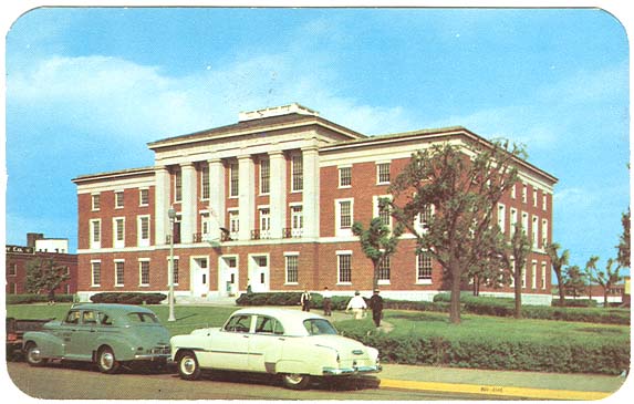
Handbook of Fort Smith Demolished in the 1930s to make way for the construction of the present Sebastian County Courthouse at the same site bounded by the streets of Rogers, Parker, Sixth and Seventh, the ornate clock tower shown here was replaced in the early 1900s by a plainer, shorter square tower. Two factors, inferior materials and a very heavy bell that vibrated the structure, threatened to shake it apart. Courtesy Handbook of Fort Smith 
Ketchum Iron Works was located on South Third Street, probably not far from the Poteau River. For a time, William N. Ayers served as president of the company. A number of Ketchum cast iron architectural pieces, mostly posts, still can be seen in the facades of some Garrison Avenue buildings. Courtesy Handbook of Fort Smith 
When the “Handbook” was published in 1887, this building was still being constructed on the corner of South Sixth Street and Rogers Avenue, facing east toward the Sebastian County Courthouse. Judge Isaac C. Parker moved his federal district court to it circa 1889. Courtesy Handbook of Fort Smith 
Bar of the Hotel Main which once stood just to the east of the First National Bank building on the south side of the 600 block of Garrison Avenue. 
Dining room of the Hotel Main which once stood just to the east of the First National Bank building on the south side of the 600 block of Garrison Avenue. 
Sitting room of the Hotel Main which once stood just to the east of the First National Bank building on the south side of the 600 block of Garrison Avenue. 
This panoramic photo probably was taken from the top of the Goldman Hotel in 1910 after it was framed out, but before its construction was completed. Notice the buildings at Texas Corner where the downtown post office is today and the buildings across Towson Avenue from them where the Friedman-Mincer was built just a few years after this photo was taken. Like the 1922 panorama, the image seen here is a composite of four photos. Courtesy of Chloe Lamon 
This panorama is a composite done from four prints, possibly copies from the original negative. The point of view appears to be from the top of the old Goldman hotel at Garrison Avenue and North 13th Street. Notice the homes that are still present in the foreground at the east end of the avenue, the building where Cisterna Park is today, the trolley car traveling up the center of the street and all the other elements in this amazing black and white image. Courtesy of Chloe Lamon 
The Manhattan Cafe stood on the south side of Garrison Avenue in the 600 block between the First National Bank and the old Hotel Main. Courtesy of the Catsavis Collection 

The Splendid Cafe in downtown Fort Smith. Courtesy of Catsavis Collection 
Members of Fort Smith Twins baseball team. Courtesy of Jim Sanders 
Looking south, probably from the rooftop of a building on the north side of Garrison Avenue, Union Station circa 1911 in the 700 block of Rogers Avenue is clearly visible. Take a close look at the buildings in the neighborhood of the train station that are no longer there. Union Station, aka Kansas City Southern Station, was built as a rail passenger facility in 1911 and demolished in 1966. Courtesy of H.E. Huber 
Fort Smith High School, circa 1920s, was also home to Fort Smith Junior College. The same building and later additions serve as Northside High School today. Courtesy of Don Marquette 
The D.J. Young home stood on West Dodson Avenue. What became of it is currently not known. West Dodson is the section of street between Towson and Wheeler avenues that is today simply designated “Dodson Avenue” as is the rest of the avenue between Greenwood and Towson avenues. Young apparently was a lumber dealer. Courtesy of H.E. Huber 
In 1968, Fort Smith’s downtown commercial district still bustled in this image looking toward the west. The Goldman Hotel’s three wings are clearly visible in the center foreground of the photo. The hotel was torn down in 1994. Courtesy of Chuck Raney 
In this undated postcard image, the Union Depot stood on the south side of the 700 block of Rogers Avenue from 1911 to 1966. Today (2005), the Holiday Inn City Center occupies approximately the same ground. Courtesy of Don Marquette 
The Ward Hotel on the northwest corner of North Sixth Street and Garrison Avenue was built by the Ward family in the late 1920s. Today (2005) after remodeling, it serves as an office building. Courtesy of Don Marquette 
“Negro Boys Club,” Fort Smith Arkansas Courtesy of Beyer Family 
Bill Jeffrey Memorial Boys’ Club was dedicated June 2, 1957, at North 50th Street and Kinkead Avenue in Fort Smith. Mr. and Mrs. W.D. Jeffrey and Mr. and Mrs. Stanley E. Evans gave the $50,000 building to the Boys club and the community as a memorial to the Jeffrey’s son, Bill Jeffrey was killed in a motor accident in 1955. The Sebastian County land was donated under the leadership of Judge Ben Geren. Clarence Higgins, Boys Club director, said in 1957 that in conjunction with the operation of the club at 215 Wheeler Avenue the two would provide room for 500 boys. Courtesy of Beyer Family 
William Jeffrey 
In 1914, St. Louis, Iron Mountain & Southern Engine 5511 rests on a Fort Smith railroad track (near Coke Hill?). The Meek Coca Cola building is visible in the background. The date of 1904 in the lower lefthand corner of the image indicates when 5511 was built. Courtesy of H.E. Huber 
Dedicated May 12, 1916, Fort Smith’s flag displays the city’s state and national allegiances in its colors and seal. The city seal bears elements from the state seal such as the state’s motto, “Regnat Populus” or “The People Rule.” The red, white and blue elements represent Fort Smith’s loyalty to the United States. According to the flag’s dedication speech, gold is meant to symbolize the city’s solidity. This version of the flag is missing the city’s motto though. The original flag read, “All for One, One for All” around the seal. Courtesy of Fort Smith Parks Department 
In the upper lefthand corner of the municipal flag, the city seal rests on a field of gold. It incorporates elements from the state seal such as the state motto, “Regnat Populus,” Latin for “The People Rule.” Goddess of Liberty and bald eagle elements represent common American symbols of freedom and virtue. The angel at the left symbolizes mercy and the sword stands for justice. A steamboat, bee hive, plow and a bushel of wheat represent the town’s industry, ties to agriculture and its character as a river town. The six stars to the left of Liberty probably denote the six countries that governed Arkansas at one time. The five stars to her right may stand for the Five Civilized Tribes that once laid claim to Western Arkansas and passed through the region on their way to the Indian Territory in the Trail of Tears. Courtesy of the Fort Smith Parks Department 
In the upper lefthand corner of the municipal flag, the city seal rests on a field of gold. It incorporates elements from the state seal such as the state motto, “Regnat Populus,” Latin for “The People Rule.” Goddess of Liberty and bald eagle elements represent common American symbols of freedom and virtue. The angel at the left symbolizes mercy and the sword stands for justice. A steamboat, bee hive, plow and a bushel of wheat represent the town’s industry, ties to agriculture and its character as a river town. The six stars to the left of Liberty probably denote the six countries that governed Arkansas at one time. The five stars to her right may stand for the Five Civilized Tribes that once laid claim to Western Arkansas and passed through the region on their way to the Indian Territory in the Trail of Tears. Courtesy of the Fort Smith Parks Department 
Dr. W.W. Bailey’s residence and office, circa 1887, was located a few blocks east of the riverfront area. Bailey was the son of Dr. Joseph H. Bailey, an Army surgeon at Fort Gibson, Indian Territory. He was schooled in Michigan, served in the Union Army as a surgeon during the Civil War and married Miss Lillie Main, daughter of Dr. J.H.T. Main. Courtesy of Handbook of Fort Smith 
Bocquin and Reutzel’s block was a solid brick and stone building on Garrison Avenue, also circa 1887. Courtesy of Handbook of Fort Smith 
Original Boston Store. Courtesy Handbook of Fort Smith 
The Fort Smith Elevator was a weekly, city newspaper which was in publication in the late 19th century. Courtesy Handbook of Fort Smith 
The old Merchants Bank in the Eberle building on the northeast corner of North Sixth Street and Garrison Avenue, circa 1887. The bank was founded in 1882 by William Joseph Echols. In 1907, it moved into new quarters at 623 Garrison, at the northeast corner of North Seventh Street and Garrison Avenue. It remained a core, Fort Smith financial institution until its purchase in the 1990s by a larger regional bank. Courtesy Handbook of Fort Smith 
St. Anne’s Academy was completed in September 1903. English-Gothic architecture of white stone and yellow brick. Construction started in August 1901. The basement had a dining hall for students, a store room, pantry and lavatories. On the first floor were four music rooms, four classrooms, a kindergarten and a reception room. Classrooms, a book store and offices occupied the second floor. More classrooms, an art room, a senior room and storage topped out the building. Hardwood floors were throughout the building and the doors were made of solid oak. From 1930 to 1973, St. Anne’s operated as a high school. It had become co-educational in 1926. It was demolished in 1974, although its last class had an enrollment of 282. Courtesy of Don Marquette 
St. John’s Hospital was Fort Smith’s first hospital. It is known today as Sparks Regional Medical Center. The original building in 1887 was the rented Nedry building at North Fourth and G streets. It was named St. John’s Hospital, probably because it was founded by the Rev. George Degan, rector of St. John’s Episcopal Church in Fort Smith. However, a meeting called in April 1893 for determining if the hospital was a church institution or not decided that it was not. In 1888, the facilitiy was moved to 302 Second Street in 1888, the old Atkinson home. In 1899 it was consolidated with a charity hospital under the Belle Point Hospital name. Courtesy of Don Marquette 
Ground for the St. Scholastica Convent was broken Dec. 18, 1923. The cornerstone was laid March 3, 1924. The building was completed in the spring of 1929 at a cost of $225,000. A new high school building was constructed in 1958 and valued at $1.8 million. St. Scholastica Convent was founded a Shoal Creek in 1879 but the Bendictine Sisters moved the motherhouse to Fort Smith in 1925 and moved the school that they ran to the city the year before. Until 1944, grade school students, both boarding and day, attended the academy along with high school girls. The school was closed in 1958 because of declining enrollments. St. Scholastica Convent under went a name change to St. Scholastica Monastery in 1986. Courtesy of Don Marquette 
The Fort Smith Country Club on Midland Boulevard was burned in the early 1920s. The current location today is now used as the Forest Park Cemetery office. It is the second oldest golf course west of the Mississippi in use at its original location, nine holes of the course remaining on the east side of the boulevard. Courtesy of Don Marquette 
]The Bennett Hotel once stood on the northeast corner of North Sixth Street and Garrison Avenue. This tinted postcard image probably dates from sometime in the 1920s or 1930s. Check out an 1880s engraving of how the building probably looked when it was new. Courtesy of Chuck Raney 
Looking north at Sixth Street from Rogers Avenue toward Garrison Avenue, you can see buildings in the foreground right and left that are no longer know. The footprints of both are now occupied by parking lots. The building on the right is the Kennedy Building built by Allen Kennedy. Milton Kennedy, his father, was a cotton broker who relocated to Fort Smith in the 1920s. His son Allen was a city councilman and insurance broker. Courtesy of Don Marquette 
The Garrison Avenue or Free Bridge opened in May 1922, connecting the downtown thoroughfare to eastern Oklahoma and spanning the Arkansas River. This is a view looking east from the bridge. Courtesy of Don Marquette 
Federal Courthouse and Post Office in Fort Smith was built circa 1937 by the Works Progress Administration. It was constructed behind the old 1890s era federal courthouse where Judge Isaac Parker heard the last cases of his judicial career. Once finished, the old courthouse was demolished. It’s seen here probably sometime in the late 1940s or early 1950s. In the 1990s, it was renovated and the post office moved to the downtown station on Garrsion, built in 1994. The courthouse was rechristened the Judge Isaac Parker Building around that time. Courtesy of Don Marquette 
The Garrison Avenue or Free Bridge opened in May 1922. Eastern Oklahoma is visible in the background. Many of the buildings to the right were demolished when the present bridge (2006) was built in the early 1970s. To the left, part of the old Frisco train station is visible. See another image of the buildings north of the bridge. Courtesy of Don Marquette 
Federal Courthouse and Post Office in Fort Smith was built circa 1937 by the Works Progress Administration. It was constructed behind the old 1890s era federal courthouse where Judge Isaac Parker heard the last cases of his judicial career. Once finished, the old courthouse was demolished. It’s seen here probably sometime in the late 1940s or early 1950s. In the 1990s, it was renovated and the post office moved to the downtown station on Garrsion, built in 1994. The courthouse was rechristened the Judge Isaac Parker Building around that time. 
The Garrison Avenue or Free Bridge opened in May 1922. Eastern Oklahoma is visible in the background. Many of the buildings to the right were demolished when the present bridge (2006) was built in the early 1970s. To the left, part of the old Frisco train station is visible. See another image of the buildings north of the bridge. Courtesy of Don Marquette 
St. Edward Mercy Hospital was dedicated on Oct. 30, 1923. In 1927, it became known as the “baby hospital” when the top floor was added to include a nursery and maternity ward. Because of overcrowding, the hospital was expanded in 1943 to give it a 150-patient capacity. Courtesy of Don Marquette 
Skateland roller rink once stood on Midland Boulevard. Don and Laura Jarrell (Mom and Pop Jarrell) moved to Fort Smith in 1945 and bought the Midland Boulevard rink in 1946. Their sons, Jack Jarrell, and Al Mechling, helped them run Skateland on Midland. It thrived until 1959, when it was demolished when the Jarrells retired. Courtesy of Bobby Jarrell 
A group of unidentified skaters pose for a photo inside Skateland roller rink on Midland Boulevard, probably sometime in the 1950s. Don and Laura Jarrell (Mom and Pop Jarrell) moved to Fort Smith in 1945, and bought the Midland rink in 1946. Their sons, Jack Jarrell, and Al Mechling, helped them run Skateland on Midland. It thrived until 1959, when it was demolished when the Jarrells retired. Courtesy of Bobby Jarrell 
The Boston Store once stood in the 700 block of Garrison Avenue on the south side facing north. It was a popular department store in Fort Smith for many decades. Courtesy of Chuck Raney 
The Masonic Temple once was located at the corner of North 6th and C streets. Although the top floor burned and was removed, the remainder still stands today (2006) and houses an architectural firm. Courtesy of H.E. Huber 
The Masonic Temple on the corner of North B and 11th streets was built in the early 1920s and still stands there. For many years, it doubled as a movie theatre as well. Courtesy of H.E. Huber 
This Mill Creek School building stood along U.S. 71 (Towson Avenue) from the 1930s to the 1960s. It housed the elementary grades of children from the Mill Creek community that existed just beyond the southern city limit of Fort Smith. An earlier school building housed the grades before it at a nearby location. Courtesy of Barbara Kell 
Benjamin Bonneville (1796 to 1878) lived in this house in the latter part of his life. Later, it served as the clubhouse for the Rolling Knolls golf course along North O Street. A native of France, Bonneville was a Army officer, a trapper and an explorer. The residence commonly called the Bonneville House on North Seventh Street in Fort Smith was the home of his young widow, Sue Neis Bonneville, shortly after his death. His first wife and daughter died in St. Louis of contagious illnesses during the Civil War. Courtesy of Dusty Helbling 
The U.S. Jail as pictured circa 1870s on a 1911 postcard was the soldiers’ barracks prior to the Civil War. It became a courtroom and jail before Isaac C. Parker took over as federal judge of the Western Arkansas District and Indian Territory in 1875. All prisoners were kept together in the basement jail which was lice riden and rat infested. As many as 110 men were kept there at one time. Bad press reports of the jail eventually resulted in action taken to alleviate the terrible sanitary conditions. in 1887-1888. A new three-story brick building was constructed adjoining the court house. Courtesy of Don Marquette 
Originally located on North 15th Street, Peabody elementary school was built in 1905 and named for George Peabody of Massachusetts, who contributed heavily toward the building of the first school. With 18 classrooms and teachers, Peabody School was located between South 20th and 21st streets off Rogers Avenue, and today the building serves as the district’s Adult Education Center. Because of overcrowding problems at the high school level, some high school classes were held there in the 1960s. Courtesy of Don Marquette 
First Christian Church was founded in 1854. It was located at North Sixth Street between North C and D streets. Efforts to expand and complete the church were suspended as a result of the civil war in 1861, then renewed and completed in 1870. A new building was completed in 1886 to accommodate a larger and growing congregation, and the sanctuary building shown here was built in 1903. In 1961, a six-acre tract was purchased at 3600 Free Ferry Road and Rogers Avenue at a cost of $97,500. Ground breaking services were held in August 1965 and dedication ceremonies on June 20,1966. Courtesy of Don Marquette 
Construction of the Friedman-Mincer Building was completed circa 1911 at Texas Corner, the intersection of Garrison Avenue, Towson Avenue and North 11th Street. Because the road was part of a route to Fort Towson in Texas, the intersection became known as Texas Corner. The three-story structure is made of white, tiled brick. Courtesy of H.E. Huber 
Looking east on Garrison Avenue from the 500 block of the street circa 1901 to 1907, the First National Bank building is visible as the fourth building from the right and on the southeast corner of the intersection of the avenue and South Sixth Street. The corner remains the home of the bank in 2006, but it makes its home in the eight story, white tile brick building constructed at the same location. Construction of the current bank building was begun in 1909 and finished in 1910. The Hotel Main is visible just to its left. Across Garrison, first on the left, the Eberle Block stood. It was the first home of Merchants National Bank. Check out these views of the Eberle Block and the Bennett Hotel that later occupied it. Courtesy of Don Marquette 
Architect W.H. Blakely designed the 1905 brick building for the Sisters of Mercy hospital known as the St. Edward’s Infirmary. An old frame building that had been used as a convent was veneered with brick, wide porches and the Corinthian columns shown here. The original infirmary, located on North 15th Street, had accommodations for 30 patients, expanded to a 40-patient capacity in 1907. Because St. Edward was the patron saint of the Most Reverend Edward Fitzgerald, second bishop of the diocese, the name was selected. On October 29, 1924, the name was officially changed to St. Edward’s Mercy Hospital, incorporating the name of the order. The hospital had since moved into a new hospital building on the same site about a year earlier. During the administration of Sister Mary Mary Maurelia Petrus, the possessive was dropped from the name, making it St. Edward Mercy Hospital in 1966. In 1975, the hospital again moved to a new location at Wildcat Mountain Road and Rogers Avenue. It is now known as St. Edward Mercy Medical Center. The postcard is from July 9,1909. Courtesy of Don Marquette 
Electric Park, circa 1916, was built at a cost of $100,000 with the grand opening in the summer of 1908. It had rides, an auditorium, roller coaster and a pavillion. In 1920, there were 5 million paid fares on 58 trolley cars. The park was built to encourage riders to the park for entertainment and of course to generate business and revenue for the streetcar line. It all came to an end in 1933. Courtesy of Don Marquette 
The Goldman Hotel was started in 1908 by the Sebastian Hotel Company. When funds ran out, the Southwestern Hotel Company was formed and completed the hotel in 1911. Between 1911 and the beginning of the war in 1941, the Goldman Hotel was the showpiece and focal point of Fort Smith society.The hotel operated until 1959 when the building was sold. Courtesy of Don Marquette 
The Free Bridge or Garrison Avenue Bridge extended from Fort Smith to the Oklahoma border over the Arkansas River. This photo postcard of the bridge looks west into Oklahoma from Fort Smith during the flood of 1927. The Missouri Pacific Railroad pushed 25 cars of coal onto the bridge to keep it from being swept away by the flood waters. Courtesy of Don Marquette 
The First National Bank building on the southeast corner of North Sixth Street and Garrison Avenue was built circa 1910 and remains today as one of the tallest buildings on the avenue. The Hotel Main to its left was constructed decades earlier in the 1880s and named for one of its builders, Dr. J.H.T. Main. First National demolished it sometime in the 1950s to make way for parking. Note the buildings to the right along Sixth Street none of which are still standing today. Another view of the same buildings. Courtesy of Don Marquette 
The east end of Garrison Avenue is seen here in the 900 block and looking west in this picture postcard from an image taken circa 1900. Courtesy of Don Marquette 
Looking east on Garrison Avenue from just west of North Sixth Street and Garrison, this image shows the First National Bank (multistory white brick) building and the Hotel Main on the right. Note the electric trolley tracks down the center of the street and the continued presence of wagons, dating this image to sometime in the 1910s. Courtesy of Don Marquette 
The Harry G. Barr Co. and Goff Bros. Grocery occupied the old Opera House building on the southwest corner of North Fifth Street and Garrison in the 1940s. The building was later demolished to make room for a bus station. Courtesy of Chuck Raney 
George Tilles, circa 1926, died November 1929. He leased and managed the Opera House in Fort Smith for many years in the late 19th century. Tilles was an entrepreneur at a young age in Fort Smith, taking over the cigar manufacturing and sales business a few years after the death of his father, Louis Tilles, when he died in 1875. At the time, George Tilles — born Sept. 11, 1859 — was only 18. See Talk with Tilles by Nancy Ellen Carver for more information on him and the Tilles family. Courtesy of the Fort Smith Public Library 
Gordon Kelley, left, Carolyn Pollan and Pat Kelley sit with the Fort Smith Land Record book in front of them. The Leigh Kelley family and the board of the Fort Smith Historical Society donated the book to the library in November 1978. It contains land records for land in the county from 1828 to 1855. Almost all of the records for much of the 19th century were lost in the courthouse fires in Fort Smith in 1872 and Greenwood in 1882. Courtesy of the Fort Smith Public Library 
Courtesy of the Fort Smith Public Library The entire staff of the Boston Store at Central Mall poses in front of the store circa 1980. The store had a long and storied history in Fort Smith until its closing in the 1980s. It moved to the mall from downtown in the 1970s. Complete identifications of everyone in the photo. Captions with complete list of names in next photo. 

Presentation of the Fort Smith Land Record Book to the Fort Smith Public Library by the Leigh Kelley family and the board of the Fort Smith Historical Society; Missy Cole Carroll, left, Fadjo Cravens Jr., Mrs. Pat Kelley, Joe Barron, Phil Miller, Thelma Wray, Gordon Kelley, Amelia Martin and Violet Burton. Courtesy of the Fort Smith Public Library 
Elizabeth, left, and Charles Bracht built a home in 1866 on what is today North 13th Street. It was demolished in the 1990s. Elizabeth Bracht was a daughter of Casper Reutzel, an antebellum settler and merchant in Fort Smith. Courtesy of the Fort Smith Public Library 
A shipment of potatoes is unloaded from a riverboat in Fort Smith circa 1900. Taken from an old picture postcard, the bridge in the distance probably is the railroad bridge which joined downtown Fort Smith with eastern Oklahoma. It spanned the Arkansas River from the 1880s until the 1970s. It was demolished around the time the old Garrison Avenue bridge built in 1922 was replaced and also demolished. The original was hand-tinted with color for reproduction. The color has been removed here to reveal more detail. Courtesy of Don Marquette 
Fort Smith High School was built and opened in September 1897. It was destroyed by the tornado of January 1898 and rebuilt. Nearly all of the original 1897 structure is gone, replaced by later construction of new wings and classrooms. After World War II, it was named Darby Junior High School in honor of William O. Darby, a Fort Smith native and founder of the modern Army Rangers. Courtesy of the Fort Smith Public Library 
C.A. Paden, a Fort Smith police officer, circa 1903. Courtesy of Chuck Raney 
Born Sept. 11, 1849, John Frank Weaver., son of W.J. and Catherine Weaver, was a Fort Smith newspaper man for 53 years. Among the papers for which he worked or which he managed was the Fort Smith Elevator, the New Era, the Daily Tribune, the Fort Smith Times and the Fort Smith Times Record. Courtesy of Chuck Raney 
Lincoln Beachey (1887 to 1915) became the first airmail pilot to deliver mail for Fort Smith on Nov. 4, 1911. Flying a Curtiss Pusher, he departed League Park (near today’s Kay Rodgers Park) and dropped a bag of mail on the lawn near the Rogers Avenue post office minutes later. It was the second air mail delivery ever in the United States. Courtesy of Chuck Raney 
Lewis Francis Hadley was linguist, artist and inventor who lived in the Indian Territory in the late Victorian period. He made a study of a sign language common used for communincation between numerous Plains Indian tribes that spoke different languages. Hadley wanted to translate the “element of the Christian faith” into this sign language to facilitate missionary work. According to a “Chronicles of Oklahoma” essay, the Rev. George Degen, rector of St. John’s Episcopal Church in Fort Smith, and his wife raised funds to support his work. Mrs. Degen even traveled through New England on a public speaking tour for this purpose. Hadley visited Fort Smith from time to time and always lived in a tent when he did. Courtesy of Chuck Raney 
St. Anne’s Academy, left, stood next to Immaculate Conception Church at North 13th Street and the end of Garrison Avenue. The Goldman Hotel later would obscure part of the view of St. Anne’s and its absence helps date this photo at some time between 1900 and 1910. Courtesy of Carole Barger 
Constantino’s restaurant did business for many decades on Garrison Avenue. The space later was home to Juanita Bollin’s Dining Emporium and now is home to Jerry’s Country Kitchen in the 400 block of the avenue. Many of these buildings, shown here in the 1960s or early 1970s, still stand. Courtesy of Chuck Raney 
First Baptist Church, located at North Thirteenth and Grand Avenue, was organized Dec. 1,1857 at the residence of William H.Byers by the constituent members. Reverand R.L. Compere wascalled as the pastor. In 1869, the congregation bought two lots at the site mentioned above. Because of the Civil War, the building was not completed until 1885. On Tuesday, January 11,1898, a cyclone crossed the city and destroyed the church. The new church was completed on Oct. 22,1899. The auditorium was first used in 1903. The building was remodeled in 1927. Courtesy of Don Marquette 
In 1885, the “old Belle Point School ” was erected at South Ninth and Wheeler. In 1886, on the “old Belle Grove site”, a new school; was erected which served as the Fort Smith High School until 1897. On january 11,1898, the school was only three months old when a cyclone almost totally destroyed it. The chimneys collapsed almost demolishing the buildings front exterior, and the roof was completely blown away. The classes were once again removed to Belle Grove as the restoration was completed rather quickly. Courtesy of Don Marquette 
Assistant claim agent Julius Hoech stands leaning on a radiator in the Union Station lobby. Special Officer Jno Tisdale stands to the left of him. Union Station served Fort Smith from 1911 to 1966 when it was torn down to make way for the construction of the Fort Smith Municipal Auditorium. The Holiday Inn City Center stands about where it did in the 700 block of Rogers Avenue. Courtesy of Warren and Tillie Cailleff 

The original KCP&G freight and passenger depots was on the southeast corner of South B and Seventh Streets, where the OK Feed Mill is now (2007). It was later replaced by the Union Station (Kansas City Southern) depot, which was built in 1911. Courtesy of Warren and Tillie Cailleff 
Workers use a tractor to haul materials at Burke Brothers brick plant along Old Greenwood Road circa 1906. Acme Brick purchased Burke in 1910. Courtesy of Jim Sanders 
This municipal Christmas tree stood in the Garrison Avenue park in 1914 that is today (2007) the space occupied by Cisterna Park, Bercher Tire and Days Inn and between North 10 and 11th streets and Garrison Avenue and North A Street. Courtesy of Gary Chamblee 
The roofs of buildings on the north side of the 300 block of Garrison Avenue are visible in the foreground followed by the fronts of the buildings on its south side. Behind them are buildings in the 300 block of Rogers Avenue and the flooded land south of the avenue during the flood of 1927. Left to right, the business in the buildings on the south side of Garrison are: Marland Refining Company Station — number 16 (404); Fort Smith Seed Co. (322-324); Hotel LeFlore (316); Quality Seed Store (312) and Reynolds Davis Grocery Co. (300-306). The four-story Atkinson Williams building is visible in the 300 block of Rogers. Courtesy of Jim Sanders 
From 1838 to 1871, the second Fort Smith served as a military establishment just a few hundred yards east of the site of the first fort. Army officers were quartered in this building there until it burned down in 1870. Courtesy of the Fort Smith Museum of History 
Mystery still surrounds the death of Belle Starr in 1889. The “Outlaw Queen” was connected with a number of criminals who resided or hid out in the Indian Territory. She was the mother of an infamous, Fort Smith madam, Pearl Starr. Courtesy of Chuck Raney 
Union soldiers encamped at Fort Smith during the Civil War at different times. Union forces abandoned it without a fight in 1861, briefly reoccupied it later then permanently retook it in September 1863. This image may date from that time period. Courtesy of the Fort Smith Museum of History 
Some of the lawmen of the Western District of Arkansas; seated left, Chris Madsen; William Grimes, U.S. marshal; and the Hitchcock girls. Standing left: Heck Thomas; a jailer; I.S. Proctor of El Reno; Tillman Dilly and Warren Cleaver, chief clerk. Courtesy of Chuck Raney 
John Rogers died in 1859 after selling land along the Arkansas River to the federal government for the construction of the second Fort Smith in the 1830s and 1840s. Although he can’t be credited with founding the military Fort Smith in 1817, he shares considerable responsibility for the second and for keeping the town alive in the interim period. He’s also credited for laying out Garrison Avenue and owned much of the land inside the original boundaries of the city of Fort Smith. Courtesy of Chuck Raney 
This hand-tinted, picture postcard shows visitors entering the front gate to Electric Park. Located at the north end of Midland Boulevard, the park was built in 1905 by the Fort Smith Light & Traction Co. to get people to travel farther out on one of the northbound trolley lines. A theater, auditorium and ballroom hosted a variety of different events until they were razed in 1920. Balloon ascensions, fireworks displays, concerts and shows drew crowds along with a roller coaster and merry-go-round. Courtesy of Don Marquette 
Located at 3420 N. 31st St. near Kelley Highway, the Whittaker Swimming Pool was privately owned but open for use by the public for a small fee. Robert Poteet and Herbert Henrici owned it at various times in the 1940s. Courtesy of Chuck Raney 
Davis Drug Store operated in the 700 block of Garrison Avenue in the 1920s. If you have more information about it, please let us know. Courtesy of Chuck Raney 
U.S. Courthouse, left and circa 1890, and U.S. Jail were where Judge Isaac Parker presided over the federal district court for western Arkansas and the Indian territory from the mid-1870s to the mid-1890s. The courthouse is shown much as it appeared when it was a building for the second military fort while the jail wing was added during the court period. Courtesy of Fort Smith Museum of History 
Although grainy, this image is one of the few views of the entire grounds of old Fort Smith, ca. 1890. Looking east from Belle Point, the buildings and structures shown here are gallows, left, the LeFlore House, the jail and guard house. In the 1870s, the site and remaining buildings of the second military fort was converted to use by the U.S. Court for the Western District of Arkansas and Indian Territory. It was here that Judge Isaac Parker presided as judge for almost 20 years. Courtesy of Fort Smith Museum of History 
]U.S. Courthouse, circa 1890, where Judge Isaac Parker presided over the federal district court for western Arkansas and the Indian territory from 1875 to the mid-1890s. The courthouse is shown much as it appeared when it was a building for the second military fort while the jail wing was added later in the court period. Courtesy of Fort Smith Museum of History 
A Fort Smith & Western railroad coach stops in its tracks so its passengers can pose for this photo, probably in the late 1920s or early 1930s picture. Courtesy of Jim Sanders 
A couple of young fans sit on one of team buses the Fort Smith Giants, probably sometime in the 1940s or 1950s. The Giants were a minor league baseball farm team that was based in Fort Smith for many years and played at Andrews Field just south of the National Cemetery. Courtesy of Jim Sanders 
Two Fort Smith Light & Traction Co. trolleys ride the rails in Fort Smith in the early 20th century. The trolley, left, is electric powered, notice the arm touching the overhead electrical line. The sign on its side reads: “What the Fort Smith Light and Traction Co. Has Done In The Past Five Years To Improve The Street Car Service Of Our City. Use Gas For Fuel. Electricity For Light And Power.” A smaller, horse-drawn trolley, right, follows behind it. Its signs reads: “No One Knows Where This One Was Built. Do You?” 
On Jan. 1, 1941, the Twin City Hospital went into operation at 1717 Midland Boulevard. Built by the as a New Deal project by the Works Progress Administration, the hospital provided health care to black citizens of Fort Smith. It was expanded in 1957. In 1964, the hospital’s license expired and it was converted into a nursing home. Courtesy of Chuck Raney 
D.J. Young was the local distributor and bottler of Anheuser Busch beer in Fort Smith. His house stood on “West Dodson Avenue,” which was the section of Dodson Avenue today between Wheeler and Towson avenues. Courtesy of Joe Wasson 
D.J. Young was the local distributor and bottler of Anheuser Busch beer in Fort Smith. His house stood on “West Dodson Avenue,” which was the section of Dodson Avenue today between Wheeler and Towson avenues. Courtesy of Joe Wasson 
Originally these buildings faced out on what later was called Boston Alley and was next to the Boston Store in the 700 block on the south side of Garrison Avenue. The alley was the only way to cut across to Rogers Avenue for a long distance on that part of Garrison. After this picture was made, a building was built across to the east creating Boston Alley. Somewhere at the start of the Depression, a project enclosed this alley and after World War II it was the Boston Store Book Store. It was while digging throurh this part of the building that remains of the D.J. Young stables were found. Courtesy of Jim Sanders 
Train depots and the Garrison Avenue bridge were threatened by the high waters of the flood of 1927. The MoPac passenger depot stands left and closest to the Arkansas River. The Frisco passenger depot, center, and the MoPac freight depot, right, complete the trio of downtown railroad buildings. See the area during drier conditions. Courtesy of Jim Sanders 
Fort Smith Horse and Mule Auction Co. near the Moffett bottoms area was among the many businesses and locations inundated during the flood of 1943. Courtesy of Jim Sanders 
Tom Taylor saloon, ca. 1900, stood in the 500 block of Garrison Avenue before prohibition. Courtesy of Chuck Raney 
Workers lean against a Fort Smith Light & Traction Co. Vehicle. Courtesy of Jim Sanders 
The Johnston Transfer and Storage building on the north side of Garrsion Avenue in the 300 block was destroyed in the tornado of April 1996. It was one of several late Victorian commercial structures ruined in the wake of the disaster. Courtesy of Ben Boulden 
Built in 1871, Adelaide Hall is the second oldest building on Garrison Avenue. Developer and owner Richard Griffin began restoration work on the structure in 1994. Renewed and revived, it now is home to the Varsity Grill restaurant. Courtesy of Benjamin Boulden 
June 12, 1993 and the Reynolds-Davis building on the southeast corner of South Third Street and Garrison Avenue still stands after about a century downtown. In April 1996, a tornado destroyed this great specimen of late Victorian commercial architecture. The first floor facade was preserved by its last owner, Richard Griffin, and still stands on the avenue to mask a parking lot behind it. The Kannady building to the left of the Reynolds-Davis was demolished shortly after this photo was taken because of serious structural flaws. Adelaide Hall to its left was restored and renovated by Griffin and since the mid-1990s has been home to the Varsity Grill restaurant. Courtesy of Ben Boulden 
In the early 1990s, the late Victorian-period Speer building at 200 Garrison Avenue was restored and renovated for use as an office building. Although it survived the 1996 tornado with its masonry walls largely in tact, it suffered some roof damage. The building’s sprinkler system malfunctioned at that time. Hours of soaking and flooding from it fatally harmed the structure. By 1994, it was demolished, and the land on which it stood is now home to Pendergraft Park. Courtesy of Ben Boulden 
Dating from the 1890s, the Josiah Foster building, left, burned in early 1997 about nine months after surviving the tornado of April 1996. The western wall of the Reynolds-Davis building at Third and Garrison is partially visible at the far left. Courtesy of Ben Boulden 
Not long after the tornado struck Fort Smith on Jan. 11, 1898, Thrash-Lick Printing Co. (later Weldon, Williams & Lick) printed a booklet of photographs depicting its aftermath entitled “Photographic Views of the Great Cyclone at Fort Smith.” Taken by a photographer named Gannaway, this and other images appeared in the booklet. It was sold for 25 cents. For more information about the tornado, click here. Courtesy of Sally Chavez 
Not long after the tornado struck Fort Smith on Jan. 11, 1898, Thrash-Lick Printing Co. (later Weldon, Williams & Lick) printed a booklet of photographs depicting its aftermath entitled “Photographic Views of the Great Cyclone at Fort Smith.” Taken by a photographer named Gannaway, this and other images appeared in the booklet. It was sold for 25 cents. For more information about the tornado, click here. Courtesy of Sally Chavez 
Not long after the tornado struck Fort Smith on Jan. 11, 1898, Thrash-Lick Printing Co. (later Weldon, Williams & Lick) printed a booklet of photographs depicting its aftermath entitled “Photographic Views of the Great Cyclone at Fort Smith.” Taken by a photographer named Gannaway, this and other images appeared in the booklet. 
Not long after the tornado struck Fort Smith on Jan. 11, 1898, Thrash-Lick Printing Co. (later Weldon, Williams & Lick) printed a booklet of photographs depicting its aftermath entitled “Photographic Views of the Great Cyclone at Fort Smith.” Taken by a photographer named Gannaway, this and other images appeared in the booklet. Courtesy of Sally Chavez 
Not long after the tornado struck Fort Smith on Jan. 11, 1898, Thrash-Lick Printing Co. (later Weldon, Williams & Lick) printed a booklet of photographs depicting its aftermath entitled “Photographic Views of the Great Cyclone at Fort Smith.” Taken by a photographer named Gannaway, this map and other images appeared in the booklet. For closeup images of this 1887 map of Fort Smith, go to this page and click on the section on which you wish to zoom in. Courtesy of Sally Chavez 
Not long after the tornado struck Fort Smith on Jan. 11, 1898, Thrash-Lick Printing Co. (later Weldon, Williams & Lick) printed a booklet of photographs depicting its aftermath entitled “Photographic Views of the Great Cyclone at Fort Smith.” Taken by a photographer named Gannaway, this and other images appeared in the booklet. Courtesy of Sally Chavez 
Not long after the tornado struck Fort Smith on Jan. 11, 1898, Thrash-Lick Printing Co. (later Weldon, Williams & Lick) printed a booklet of photographs depicting its aftermath entitled “Photographic Views of the Great Cyclone at Fort Smith.” Taken by a photographer named Gannaway, this view of the Avenue from 801 to 809 Garrison and other images appeared in the booklet. Courtesy of Sally Chavez 
According to information with a copy of this image in the archives of the Ottenheimer Library at the University of Arkansas at Little Rock, the men standing here on the walls of the second Fort Smith around the gallows of the U.S. District Court are witnessing the execution of Cherokee Bill (aka Crawford Goldsby) on March 17, 1896. Photographs of the condemned at execution were prohibited by the court. This may be as close as the photographer could get to the gallows without drawing the attention and ire of court officials. Courtesy of Fort Smith Museum of History 
The Williams-Echols Dry Goods Co. and Speer Hardware Co. once were housed in this building at 200 Garrison Avenue in Fort Smith. Although renovated and used as an office building in the 1990s, it suffered extensive roof and water damage in the tornado of April 1996 and was later demolished. Courtesy of Girard Collection 
The Berry-Wright Dry Goods was housed in the Josiah Foster building, far right, on Garrison Avenue circa 1900. It burned down during renovation in early 1997. The Reynolds-Davis building, to the left of the Foster, was destroyed in the tornado of April 1996. Courtesy of Jim Sanders 
From the northwest corner of North Seventh Street and Garrison Avenue, Fort Smith’s major downtown thoroughfare appears to be decorated for the Fourth of July or an Election Day sometime between 1907 and 1910. The multi-story white brick First National Bank building has not yet been built (circa 1910/1911), but the Merchants National Bank building, masonry corner far right, has. Notice all the red-white-and-blue bunting and decorations on the Hotel Main across the street. See inside the Hotel Main. Courtesy of Chuck Girard 
The old Sebastian County Courthouse, right, stood on Sixth Street between Rogers Avenue and Parker Avenue. It was demolished in the 1930s and replaced with a new building on the same site that was constructed by the Works Progress Administration, a New Deal initiative. The Kennedy building, built circa 1907, can be seen to its left on the northeast corner of Sixth and Rogers. It too is gone as is the masonry building on the far left. This image probably dates from the 1920s. Courtesy of Jim Sanders 
Inside the Tony Euper Saloon circa 1906, a number of men line up for drinks. Notice the absence of stools and use of the brass rail along the bottom of the bar. The owner may have been Tony Euper Jr. Courtesy of Jim Sanders 
The houses of Fort Smith’s Row lined North First Street circa 1900 and provided space for the city’s legal and regulated prostitution businesses. Outside the Row, the activity was still illegal in Fort Smith. Inside the Row, it enjoyed legal status from 1907 to 1924 with madams and prostitutes paying monthly license fees and undergoing regular health inspections. Notice “Miss Laura’s,” the third building from the left and the only Row house that still stands today. See the original view of downtown Fort Smith from which this image was taken. Courtesy of the Girard Collection 
Downtown circa 1900 as seen from above the vicinity of North Third Street and Garrison Avenue looking northwest, this image shows many of the buildings that once stood on the side streets to the avenue but are gone now. Notice the houses of the Row area between the Arkansas River and the buildings in the foreground. Courtesy of the Girard Collection 
What became the Goldman Hotel is shown here under construction at the corner of North 13th Street and Garrision Avenue. Backers originally planned to name it the Hotel Sebastian, but ran into financial problems during the project. Goldman provided the additional money to complete the project and the hotel was named for him. It was completed circa 1911 and demolished in 1994. Courtesy of the Girard Collection 
Courtesy of the Archives of the University of Arkansas at Little Rock This is the only known photograph of the fire of January 7-8, 1910 at the Fort Smith Light and Traction Co. According to contemporary news accounts, the fire was caused by the explosion of an oil tank at the plant and on the corner of North First and D streets. The fire interrupted trolley service in the city, burned down some of the houses in the nearby Row area, the vice district where prostitution was legal and regulated. Because it was an oil fire and difficult to extinguish, it burned for more than 12 hours. Late on the morning of Jan. 8, a melted metal tower which held aloft a water tank collapsed. The water spread the oil fire in all directions, igniting the powerhouse. It was at that time that trolley and power service was interrupted. The fiery oil slick covered part of the Arkansas River and even ignited driftwood on a sandbar. Because of the infamy of the Row, the fire has been long remembered locally and earned the name “Night of the Lingerie Parade.” That sobriquet was bestowed on the event because legend recounts that prostitutes in the bordellos of the Row fled the threatening blaze in their bedclothes. While that certainly seems possible, no evidence exists to support a version of the story that an arsonist sought to burn down the Row out of moral indignation. One newspaper reports that the “resort of Dora Gaston” and the “resort of Jesse Collins” were destroyed in the fire, but it was not the end of commercial sex in the Row. Laura Zeigler, the madam at 123 First St., did not move away until 1911. Dora Gaston returned to re-establish her bordello after the blaze. Miss Ella Scott’s house operated well into 1920s or later. Some storytellers have asserted that the fire only left Miss Laura’s. That appears not to be the case. Several madams and houses continued to operate in the Row for many years. 
This from the lower left section of the only known photograph of the fire of January 7-8, 1910 at the Fort Smith Light and Traction Co. If you look closely at a point about a quarter of the image’s width from the left, then you should be able to see a partial view of a woman hiding behind the privacy fence. Photos of the Row are rare, but some photos of the prostitutes who worked there do exist. Unfortunately, many of them have been defaced to obscure or cutout the faces of the women. Presumably this was done by them so they could not later be identified. The ordinance legalizing prostitution in the Row area required the construction of fences around the houses of prostitution that were at least eight feet in height. According to contemporary news accounts, the fire was caused by the explosion of an oil tank at the plant and on the corner of North First and D streets. The fire interrupted trolley service in the city, burned down some of the houses in the nearby Row area, the vice district where prostitution was legal and regulated. Because it was an oil fire and difficult to extinguish, it burned for more than 12 hours. Late on the morning of Jan. 8, a melted metal tower which held aloft a water tank collapsed. The water spread the oil fire in all directions, igniting the powerhouse. It was at that time that trolley and power service was interrupted. The fiery oil slick covered part of the Arkansas River and even ignited driftwood on a sandbar. Because of the infamy of the Row, the fire has been long remembered locally and earned the name “Night of the Lingerie Parade.” That sobriquet was bestowed on the event because legend recounts that prostitutes in the bordellos of the Row fled the threatening blaze in their bedclothes. Click on the thumbnails to see closeup views of sections of the lower part of the image. While that certainly seems possible, no evidence exists to support a version of the story that an arsonist sought to burn down the Row out of moral indignation. One newspaper reports that the “resort of Dora Gaston” and the “resort of Jesse Collins” were destroyed in the fire, but it was not the end of commercial sex in the Row. Laura Zeigler, the madam at 123 First St., did not move away until 1911. Dora Gaston returned to re-establish her bordello after the blaze. Miss Ella Scott’s house operated well into 1920s or later. Some storytellers have asserted that the fire only left Miss Laura’s. That appears not to be the case. Several madams and houses continued to operate in the Row for many years. Courtesy of the Archives of the University of Arkansas at Little Rock 
This from the lower right section of the only known photograph of the fire of January 7-8, 1910 at the Fort Smith Light and Traction Co. The bystanders in this part of the image appear to be exclusively male, but they seem to come from a wide-variety of social stations and even races. In the background and high above them, the smokestacks of Fort Smith first electrical power plant soar into the sky. Photos of the Row are rare, but some photos of the prostitutes who worked there do exist. Unfortunately, many of them have been defaced to obscure or cutout the faces of the women. Presumably this was done by them so they could not later be identified. The ordinance legalizing prostitution in the Row area required the construction of fences around the houses of prostitution that were at least eight feet in height. According to contemporary news accounts, the fire was caused by the explosion of an oil tank at the plant and on the corner of North First and D streets. The fire interrupted trolley service in the city, burned down some of the houses in the nearby Row area, the vice district where prostitution was legal and regulated. Because it was an oil fire and difficult to extinguish, it burned for more than 12 hours. Late on the morning of Jan. 8, a melted metal tower which held aloft a water tank collapsed. The water spread the oil fire in all directions, igniting the powerhouse. It was at that time that trolley and power service was interrupted. The fiery oil slick covered part of the Arkansas River and even ignited driftwood on a sandbar. Because of the infamy of the Row, the fire has been long remembered locally and earned the name “Night of the Lingerie Parade.” That sobriquet was bestowed on the event because legend recounts that prostitutes in the bordellos of the Row fled the threatening blaze in their bedclothes. While that certainly seems possible, no evidence exists to support a version of the story that an arsonist sought to burn down the Row out of moral indignation. One newspaper reports that the “resort of Dora Gaston” and the “resort of Jesse Collins” were destroyed in the fire, but it was not the end of commercial sex in the Row. Laura Zeigler, the madam at 123 First St., did not move away until 1911. Dora Gaston returned to re-establish her bordello after the blaze. Miss Ella Scott’s house operated well into 1920s or later. Some storytellers have asserted that the fire only left Miss Laura’s. That appears not to be the case. Several madams and houses continued to operate in the Row for many years. Courtesy of the Archives of the University of Arkansas at Little Rock 
At the time this ticket was in use, the fair probably was held on land on which Ramsey Junior High School sits today. Fort Smith Historical Society Archives 
Ward’s Ice Cream advertised on the menu’s last page was made locally. This menu dates from around 1943. The Joie Theatre burned down in the 1950s. Fort Smith Historical Society Archives 
Ward’s Ice Cream advertised on the menu’s last page was made locally. This menu dates from around 1943. The Joie Theatre burned down in the 1950s. Fort Smith Historical Society Archives 
oday, the poll tax is seen as a way to create obstacles to voting for poor blacks and poor whites. In order to vote, a person had to pay a tax ostensibly to support the cost of elections. Fort Smith Historical Society Archives 
Paden Tolbert, U.S. deputy marshal in the 1880s and 1890s, brother of John Tolbert. John Tolbert and Paden Tolbert were deputy marshals in the federal district court presided over by Judge Isaac C. Parker in Fort Smith. This image was likely taken circa 1892 when both men took part in the killing of the outlaw Ned Christie in the Indian Territory. Fort Smith Historical Society Archives 
John Tolbert, U.S. deputy marshal from 1890 to 1902, brother of Paden Tolbert. John Tolbert and Paden Tolbert were deputy marshals in the federal district court presided over by Judge Isaac C. Parker in Fort Smith. This image was likely taken circa 1892 when both men took part in the killing of the outlaw Ned Christie in the Indian Territory. Fort Smith Historical Society Archives 


Past Postings & FAQs

The Fort Smith Historical Society of news clippings, interviews, and essays. These span a wide range of dates throughout the 1800s to early 2000s.
Questions? Check out this list of Frequently Asked Questions about the City of Fort Smith.
Who’s Who

The Fort Smith Historical Society has compiled a detailed “Who’s Who” of some of the Fort Smith region’s most prominent and impactful citizens. Many of the men and women included in this directory played a pivotal role in the establishment of the city and/or some of its most recognizable industries and entities.
Misc. Records & Directories
- Sebastian County Cemeteries Directory
- Washington Cemetery, Fort Smith, Arkansas – An African-American Burial Ground
- Massard Prairie Battlefield Park Brochure
- Northside High School Newspaper, The Grizzly (1954-1955 editions)
- Razorback Speedway News (1968 Volumes 1-27)
World War II Project

World War II ended in 1945, but we are still trying to describe and understand it. As the nation’s remaining WWII veterans into their 80s and 90s, many are ready to tell their stories, which can serve as valuable lessons for today’s generation.
Check out our extensive interview archive and photo collection honoring local veterans.
City Symbols

